Präzoll Trail | W118
It’s faster to take
the cable car…

… it may be faster to use the Mendel cable car, but it is more rewarding to walk along the Präzollsteig. The start of the Präzollsteig is at the parking lot at the valley station of the Mendelbahn. There are several signs there. We follow the No. 538 to the Präzollsteig. Just before the Altenburg sports zone, we turn right at the crossroads. Soon after that we leave the road. Here begins the ascent through the forest along a beautiful path. At several crossroads with other forest paths we always stay on no. 538 and after the deciduous forest zone we slowly enter the mixed forest zone, where beech and larch trees give us a colorful picture in autumn.
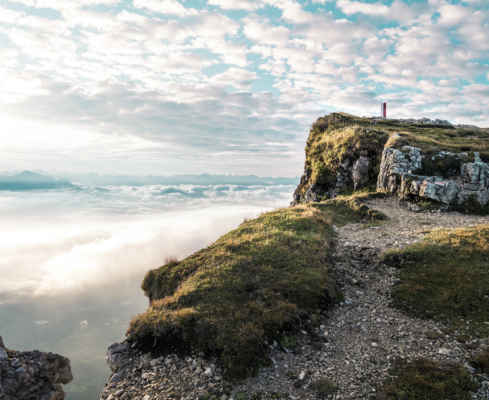
At the point where you have a good view of the valley from a rest area, you have reached the highest point of the hike. We are on the Mendel ridge and now walk along the wide forest path in the direction of the Halbweghütte, which we reach after about ten minutes. Trail no. 500 then leads directly to the mountain station of the Mendel cable car. There we can decide whether to take the train comfortably down to the valley or to walk. The trail begins at the Mendel road in the direction of Kaltern, just below the top of the pass.
It goes off to the right along the “Alter Mendelsteig”, which is marked with “M”. Despite some steep passages, the route down into the valley is easy to manage. Arrived in the Kalterer district of St. Anton, the “Mendel cable car valley station” is still well marked, so that we have reached the starting point in a short time.
Sweaty climb with over 1,000 meters of altitude gain
Quite shady through different forest zones
The view at the ridge makes you forget the effort
Starting point: Mendel cable car valley station
Pit stops: Halbweghütte, Enzianhütte
GPX-Track -km, -m GPX
| Name: | No data |
| Distance: | No data |
| Minimum elevation: | No data |
| Maximum elevation: | No data |
| Elevation gain: | No data |
| Elevation loss: | No data |
| Duration: | No data |